

DOI Seite / Zitierlink:
https://doi.org/10.11588/diglit.22272#0064


46
glasgow arclleological society.
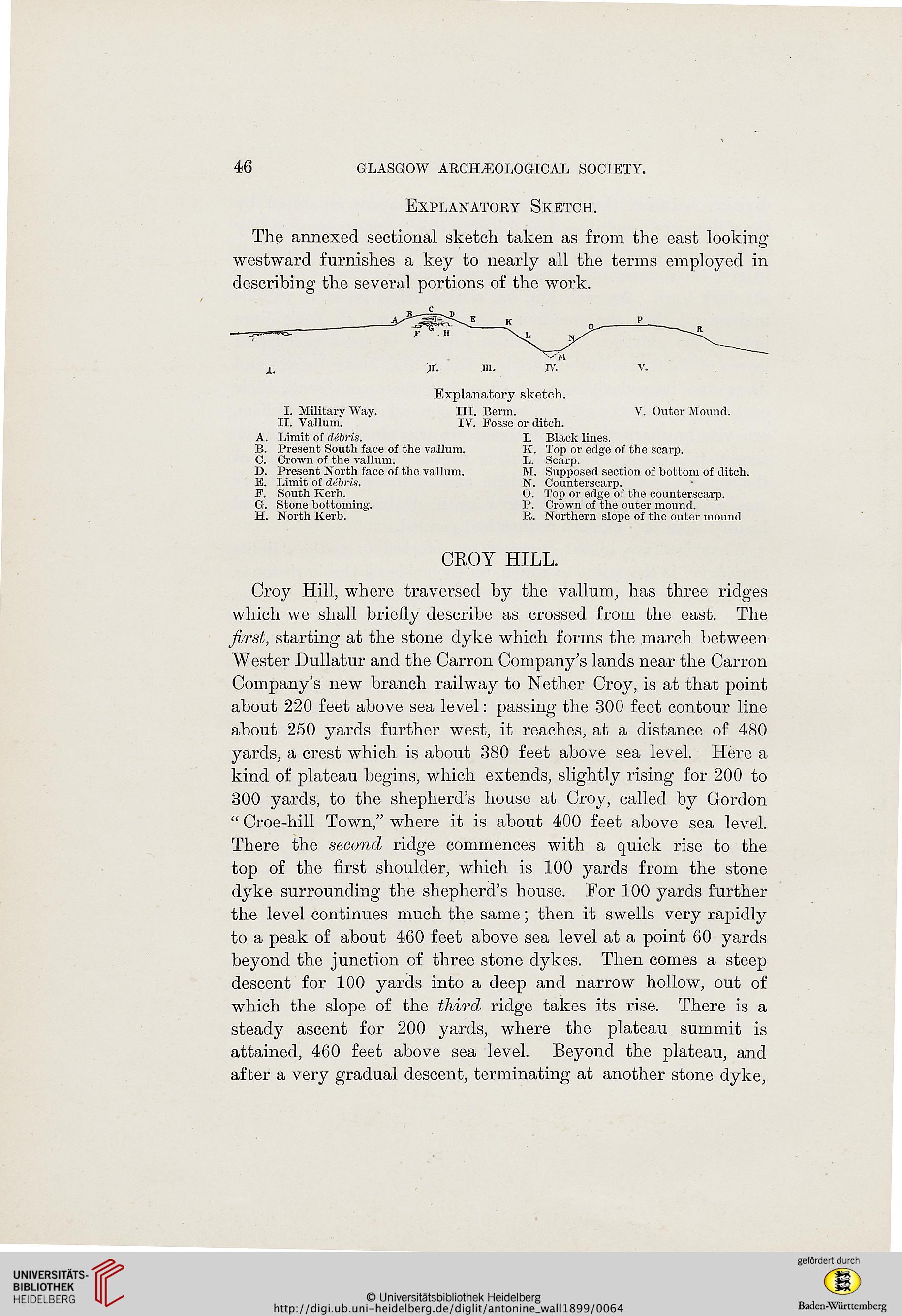
Explanatory Sketch.
The annexed sectional sketch taken as from the east looking
westward furnishes a key to nearly all the terms employed in
describing the several portions of the work.
Explanatory sketch.
I. Military Way. III. Berm. V. Outer Mound.
II. Vallum. IV. Fosse or ditch.
A. Limit of debris. I. Black lines.
B. Present South face of the vallum. K. Top or edge of the scarp.
C. Crown of the vallum. L. Scarp.
D. Present North face of the vallum. M. Supposed section of bottom of ditch.
E. Limit of debris. N. Counterscarp.
F. South Kerb. O. Top or edge of the counterscarp.
G. Stone bottoming. P. Crown of the outer mound.
H. North Kerb. R. Northern slope of the outer mound
CROY HILL.
Croy Hill, where traversed by the vallum, has three ridges
which we shall briefly describe as crossed from the east. The
first, starting at the stone dyke which forms the march between
Wester Dullatur and the Carron Company's lands near the Carron
Company's new branch railway to Nether Croy, is at that point
about 220 feet above sea level: passing the 300 feet contour line
about 250 yards further west, it reaches, at a distance of 480
yards, a crest which is about 380 feet above sea level. Here a
kind of plateau begins, which extends, slightly rising for 200 to
300 yards, to the shepherd's house at Croy, called by Gordon
" Croe-hill Town," where it is about 400 feet above sea level.
There the second ridge commences with a quick rise to the
top of the first shoulder, which is 100 yards from the stone
dyke surrounding the shepherd's house. For 100 yards further
the level continues much the same; then it swells very rapidly
to a peak of about 460 feet above sea level at a point 60 yards
beyond the junction of three stone dykes. Then comes a steep
descent for 100 yards into a deep and narrow hollow, out of
which the slope of the third ridge takes its rise. There is a
steady ascent for 200 yards, where the plateau summit is
attained, 460 feet above sea level. Beyond the plateau, and
after a very gradual descent, terminating at another stone dyke,
glasgow arclleological society.
Explanatory Sketch.
The annexed sectional sketch taken as from the east looking
westward furnishes a key to nearly all the terms employed in
describing the several portions of the work.
Explanatory sketch.
I. Military Way. III. Berm. V. Outer Mound.
II. Vallum. IV. Fosse or ditch.
A. Limit of debris. I. Black lines.
B. Present South face of the vallum. K. Top or edge of the scarp.
C. Crown of the vallum. L. Scarp.
D. Present North face of the vallum. M. Supposed section of bottom of ditch.
E. Limit of debris. N. Counterscarp.
F. South Kerb. O. Top or edge of the counterscarp.
G. Stone bottoming. P. Crown of the outer mound.
H. North Kerb. R. Northern slope of the outer mound
CROY HILL.
Croy Hill, where traversed by the vallum, has three ridges
which we shall briefly describe as crossed from the east. The
first, starting at the stone dyke which forms the march between
Wester Dullatur and the Carron Company's lands near the Carron
Company's new branch railway to Nether Croy, is at that point
about 220 feet above sea level: passing the 300 feet contour line
about 250 yards further west, it reaches, at a distance of 480
yards, a crest which is about 380 feet above sea level. Here a
kind of plateau begins, which extends, slightly rising for 200 to
300 yards, to the shepherd's house at Croy, called by Gordon
" Croe-hill Town," where it is about 400 feet above sea level.
There the second ridge commences with a quick rise to the
top of the first shoulder, which is 100 yards from the stone
dyke surrounding the shepherd's house. For 100 yards further
the level continues much the same; then it swells very rapidly
to a peak of about 460 feet above sea level at a point 60 yards
beyond the junction of three stone dykes. Then comes a steep
descent for 100 yards into a deep and narrow hollow, out of
which the slope of the third ridge takes its rise. There is a
steady ascent for 200 yards, where the plateau summit is
attained, 460 feet above sea level. Beyond the plateau, and
after a very gradual descent, terminating at another stone dyke,