

DOI Seite / Zitierlink:
https://doi.org/10.11588/diglit.20836#0001


■ >»
«> t 4 • ,
K •//'/
l ■■■/y.
« Y. W
• »• j / >
>1
■• <H < / /
/.vv/
•f <• # J
* > »' > /
• /
* »• #• ;■ »•
? - »• #• #•
i ■•.•'•/;•'
> % //•
1
i * » > 4
T f * ■
r j»r» >■ >
£• ’ <• / /•
■r * » >
• ’ ••*•#
:•*•*#•/
■■ I •■•:•:>:
i V.V
:.• i'v'
11
Ife;
£ rJ7 •
;;•(. •$-*• #• #'/•
!;'•,• v'V
U&S.
4 ’> »•> t
!»• <• #
!$>1
i ’■»'.'.•
'•'/•V'Vl : ■>
•'' * / '
. «#• >• « »
; ; • ■>• •.'
• • »• .. i.
/v:;:
l ■*> '■ * <
, y/i'i
p
| V ,
’i « ■’ * » V
» » >
*• »•
» *. ». *
• »•»•»•
v VvV
| \y,’
*......
m/
i- .■,.•,•
i -» *. »• »■
f %*•//,
I v/’
§ » > »■ »•
J * *-» l
V/’
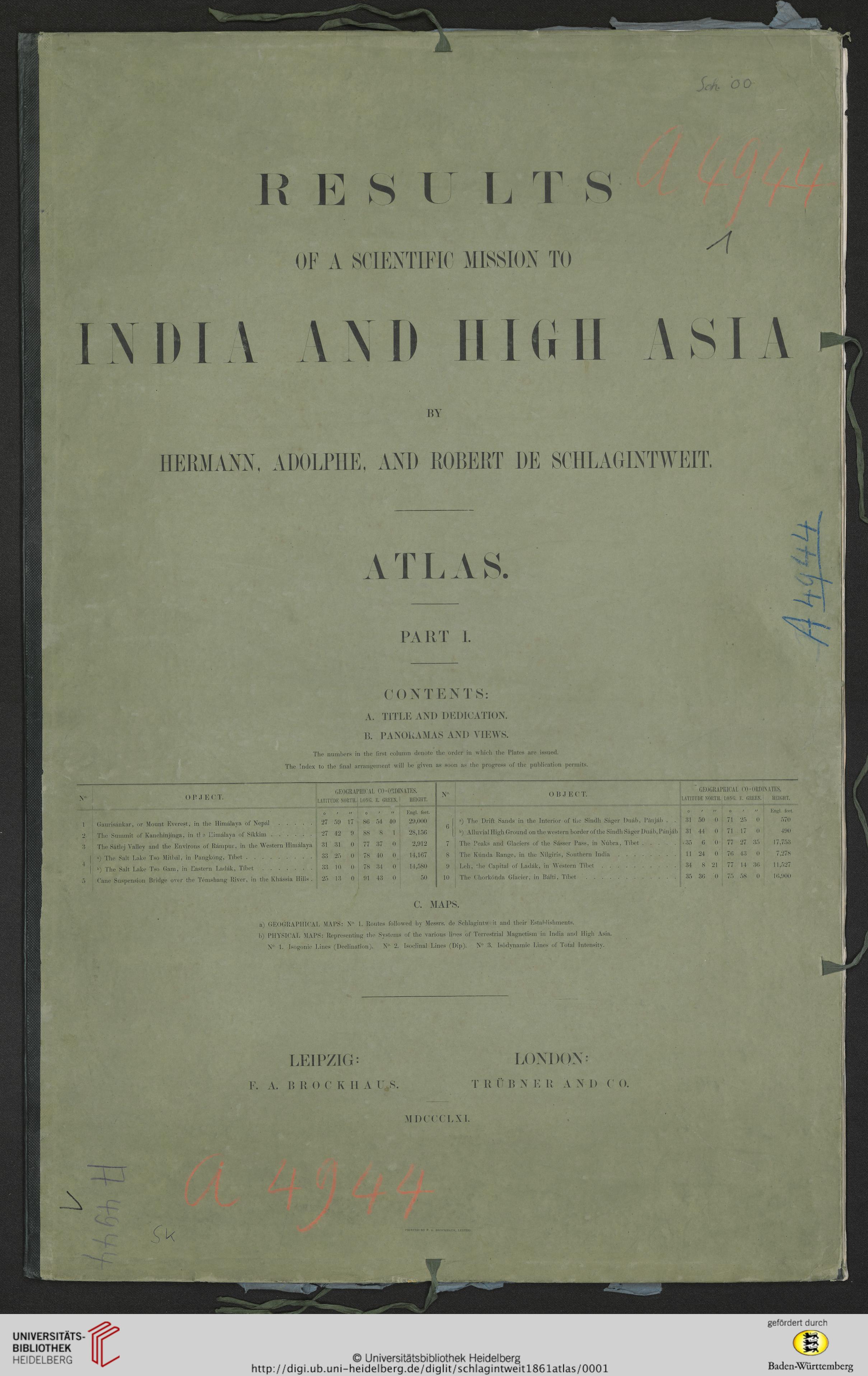
OF A SCIENTIFIC MISSION TO
BY
HERMANN. ADOLPHE, AND ROBEHT DE SCHLAOINTWEIT.
t
au
PART 1.
CONTENTS:
A. TITLE AND DEDIOATION.
B. PANOUAMAS AND YIEWS.
The numbers in the iirst colnmn denote the order in whicli the Plates are issued.
The Index to the final arrangement will be given as soon as the progress of the publication permits
X<
O P J E C T.
GEOGRAPHICAL CO-ORDINATES.
o
Gaurisankar, or Mount Everest, in the Himalaya of Nepal.
The Summit of Kanchinjinga, in tl e Ilimalaya of Sikkim.
The Satlej Yalley and the Environs of Rampur, in the Western Himalaya
a) The Sait Lake Tso Mitbal, in Pangkong, Tibet.
b) rFhe Salt Lake Tso Gam, in Eastern Ladak, Tibet.
Cane Suspension Bridge over the Temshang River, in the Khassia Hills .
LATITUDE NORTH.
LONG. E. GREEN.
HEIGHT.
0
t
tt
0
t
tt
Engl. feet
27
59
17
86
54
40
29,000
27
42
9
88.
8
1
28,156
31
31
0
77
37
0
2,912
33
25
0
78
40
0
14,167
10
0
78
34
0
14,580
25
13
0
91
43
0
50
OBJEC T.
a) The Drift Sands in the Interior of the Sindh Sager Duab, Panjab . .
b) Alluvial High Ground on the western border of the Sindh Sager Duab, Panjab
The Peaks and Glaciers of the Sasser Pass, in Nubra, Tibet.
The Kunda Range, in the Nilgiris, Southern India.
Leh, Jhe Capital of Ladak, in Western Tibet.
The Chorkonda Glacier, in Balti, Tibet ..
GEOGRAl'IilCAL C0-0RD1NATES.
LATITUDE N0RTH.
L0NG. E. GREEN.
HEIGHT.
O
t
tt
O
/
tt
Engl. feet
31
50
0
71
25
0
570
31
44
0
71
17
0
490
• 35
6
0
77
27
35
17,753
11
24
0
76
43
0
7,278
34
8
21
77
14
36
11,527
35
36
0
75
58
0
16,900
c. MAPS.
a) GEOGRAPHICAL MAPS: N° 1. Routes followed by Messrs. de Schlagintwcit and their Establishments.
b) PH\rSICAL MAPS: Representing the Systems of the various lines of Terrestrial Magnetism in India and High Asia
N° I. Isogonic Lines (Declination). N°- 2. Isoclinal Lines (Dip). N° 3. Isodynamic Lines of Total Intensitv.
LEIPZIG;
F. A. I! I: O C K II A U S
T R IT B N E R A N I) C O.
MDCCCLXI.
PKINTED BY F. A. BROCKHAUS, LEIPZIG