

DOI Seite / Zitierlink:
https://doi.org/10.11588/diglit.20836#0022


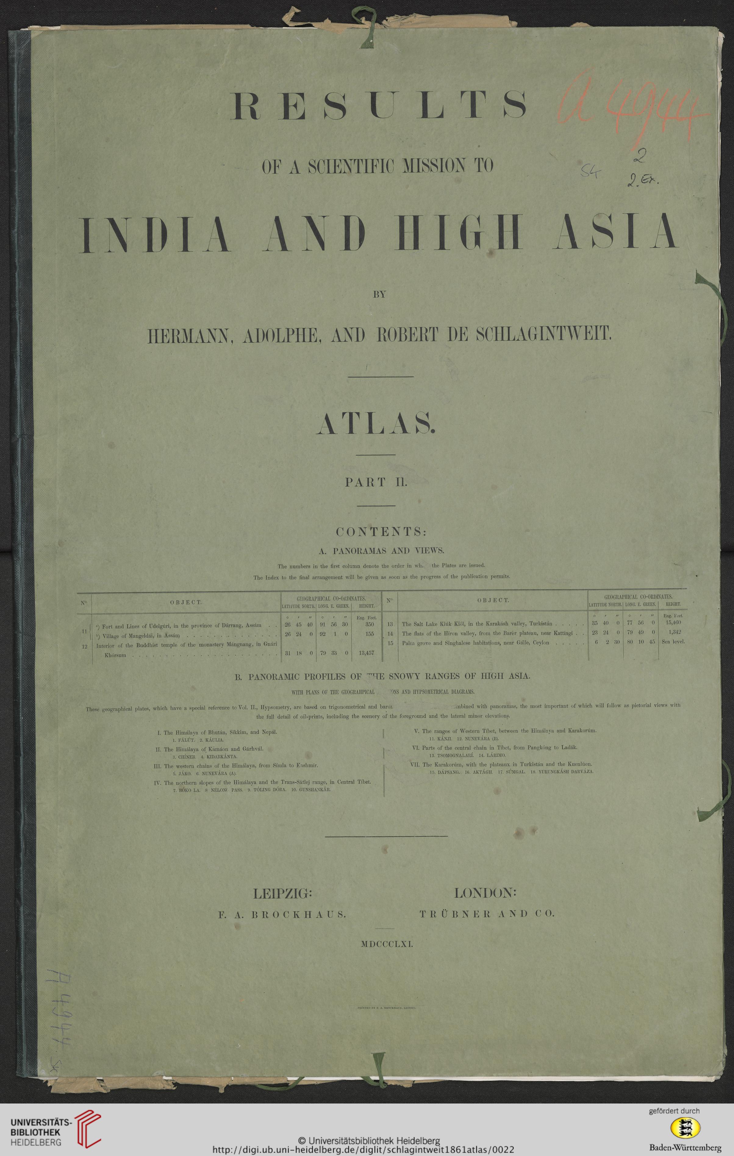
PART II.
CONTENTS:
A. PANORAMAS AND VIEWS.
The numbers in the first column denote the order in wln, the Plates are issued.
The Index to the final arrangement will be given as soon as the progress of the publication permits.
N°.
0 B J E C T.
GEOGRAI
LATlfUDE NORTR.
TIICAL CO-ORDI
LONG. E. GREEN.
NATE8.
HEIGHT.
N°-
0 B J E C T.
GEOGRA]
LATITUDE NORTH.
PIIICAL CO-ORDI
LONG. E. GREEN.
NATES.
HEIGHT.
■
11
12
a) Fort and Lines of Udelguri, in the province of Darrang, Assam . .
b) Village of Mangeldai, in Assam..
Interior of the Buddhist temple of the monastery Mangnang, in Gnari
Khorsum.
0/1/
26 45 40
26 24 0
31 18 0
o / //
91 56 30
92 1 0
79 33 0
Eng. Feet.
350
155
13,457
13
14
15
The Salt Lake Kiuk Kiol, in the Karakash valley, Turkistan.
The flats of the Hiron valley, from the Barer plateau, near Kattingi . .
Palm grove and Singhalese liabitations, near Galle, Ceylon.
O / //
35 40 0
23 24 0
6 2 30
0 / //
. 77 56 0
79 49 0
80 10 45
Eng. Feet.
15,460
1,342
Sea level.
B. PANORAJVUC PROFILES OF ^HE SNOWY RANGES OF HIGH ASIA.
WITH PLANS OF THE GEOGKAIPICAL 'ONS ASD HYPSOHETRICAL DIAGRAMS.
These geographical plates, whicli liave a special reference to Vol. II., Hypsometry, are based on trigonometi’ical and baroL .mbined with panoramas, the most important of which will follow as pictorial views with
the full detail of oil-prints, including the scenery of the foreground and the lateral minor elevations.
I. The Himalaya of Bhutan, Sikkim, and Nepal.
1. FALIJT. 2. KAULIA.
II. The Himalaya of Kamaon and Garhval.
3. CHINER. 4. KIDARKANTA.
III. The western chains of the Himalaya, from Simla to Kashmir.
5. JAKO. 6. NUNEVARA (A).
IV. The northern slopes of the Himalaya and the Trans-Satlej range, in Central Tibet.
7. BOKO LA. 8 NELONf PASS. 9. TOLING DORA. 10. GUNSHANKAR.
V. The ranges of Western Tibet, between the Himalaya and Karakoram.
11. KANJI. 12. NUNEVARA (B).
VI. Parts of the central chain in Tibet, from Pangkong to Ladak.
13. TSOMOGNALARL 14. LARIMO.
VII. The Karakorum, with the plateaux in Turkistan and the Kuenluen.
15. DAPSANG. 16. AKTAGH. 17. SUMGAL. 18. YURUNGKASH DARVAZA.
LEIPZIG*
F. A. BROCKHAUS.
LONDON:
T R U B N E R A N D C O.
MDCCCLXI.
I’KIKTED BY F. A. BIJOCKHAUS, I.F.IPZIO.