

DOI Artikel:
Sterrett, John R. Sitlington: The Wolfe expedition to Asia Minor
DOI Seite / Zitierlink:https://doi.org/10.11588/diglit.8680#0202


THE WOLFE EXPEDITION
found a large number of sarcophagi in the ancient cemetery, most of
them still in situ, but no inscriptions. From here we head east, ascend
to a pass from which Kizil Oren is visible, then descend a dere with an
inhospitable hilly country on either side to Aghris, one hour from Kizil
Oren. A small Tchai comes down a dere at the westernmost end of
Kirzil Oren Dagh : as I have already stated above, I believe that the
water from the Tulasa region finds its outlet through this dere. Still
the point remains in doubt, and the villagers of Aghris profess not to
know. At any rate, this region of country and that around Kizil
Oren form the head waters of the Sari Ozii.
August 5. Aghris, via Yonuslar (3 h. 28 m.), to Kotchieui,
8 h. 17 m. We head northwest, leaving Kizil Oren on our right,
and go down the Bagharzik Dere, down which flows the Sari Ozii.
The country is wild, and the peaks and rocks are rugged and jagged.
This is the high-road from Kara Agatch to Konia, and has always
been infested with Zeibek robbers until within the last few years.
The Dere ends a short distance before Yonuslar is reached, and at
the same time the Sari Ozii changes its direction and flows nearly
southwest.
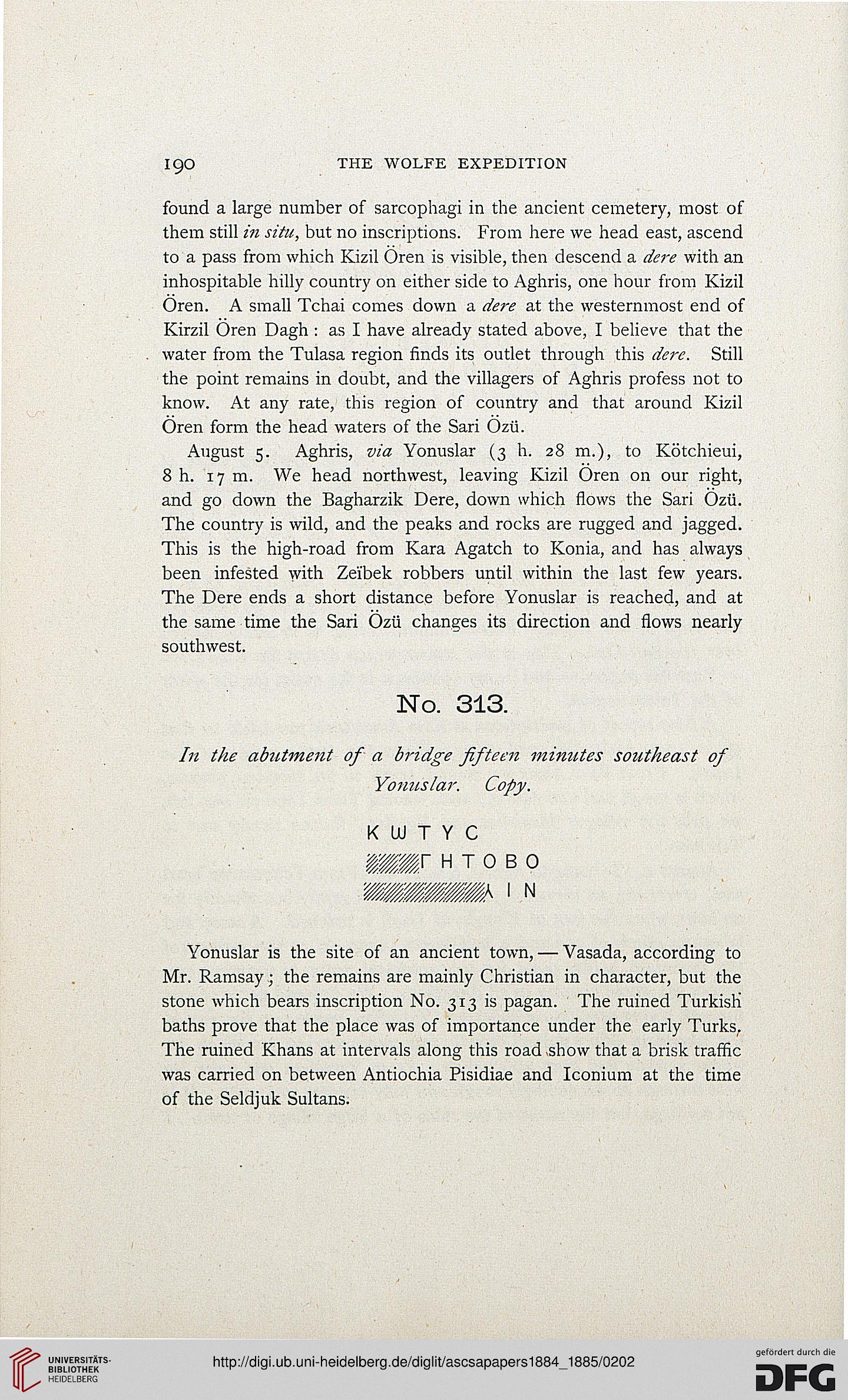
No. 313.
In the abutment of a bridge fifteen minutes southeast of
Yonuslar. Copy.
Yonuslar is the site of an ancient town, — Vasada, according to
Mr. Ramsay; the remains are mainly Christian in character, but the
stone which bears inscription No. 313 is pagan. The ruined Turkish
baths prove that the place was of importance under the early Turks.
The ruined Khans at intervals along this road show that a brisk traffic
was carried on between Antiochia Pisidiae and Iconium at the time
of the Seldjuk Sultans.
found a large number of sarcophagi in the ancient cemetery, most of
them still in situ, but no inscriptions. From here we head east, ascend
to a pass from which Kizil Oren is visible, then descend a dere with an
inhospitable hilly country on either side to Aghris, one hour from Kizil
Oren. A small Tchai comes down a dere at the westernmost end of
Kirzil Oren Dagh : as I have already stated above, I believe that the
water from the Tulasa region finds its outlet through this dere. Still
the point remains in doubt, and the villagers of Aghris profess not to
know. At any rate, this region of country and that around Kizil
Oren form the head waters of the Sari Ozii.
August 5. Aghris, via Yonuslar (3 h. 28 m.), to Kotchieui,
8 h. 17 m. We head northwest, leaving Kizil Oren on our right,
and go down the Bagharzik Dere, down which flows the Sari Ozii.
The country is wild, and the peaks and rocks are rugged and jagged.
This is the high-road from Kara Agatch to Konia, and has always
been infested with Zeibek robbers until within the last few years.
The Dere ends a short distance before Yonuslar is reached, and at
the same time the Sari Ozii changes its direction and flows nearly
southwest.
No. 313.
In the abutment of a bridge fifteen minutes southeast of
Yonuslar. Copy.
Yonuslar is the site of an ancient town, — Vasada, according to
Mr. Ramsay; the remains are mainly Christian in character, but the
stone which bears inscription No. 313 is pagan. The ruined Turkish
baths prove that the place was of importance under the early Turks.
The ruined Khans at intervals along this road show that a brisk traffic
was carried on between Antiochia Pisidiae and Iconium at the time
of the Seldjuk Sultans.