

DOI Heft:
Egypt
DOI Artikel:Herbich, Tomasz; Spencer, A. J.: Tell el-Balamun: geographical and archaeological survey, 2007-2008
DOI Seite / Zitierlink: https://doi.org/10.11588/diglit.42093#0138


TELL EL-BALAMUN
EGYPT
GEOPHYSICAL INVESTIGATIONS
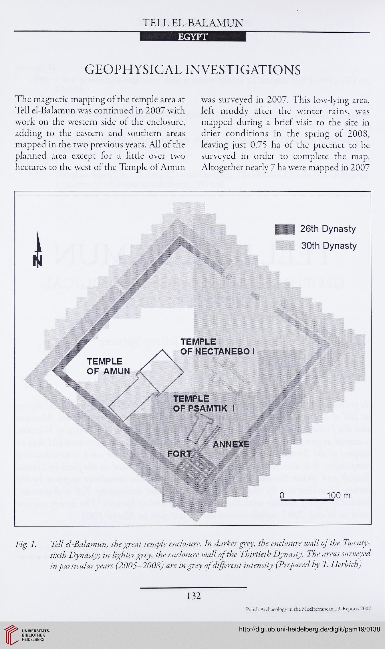
The magnetic mapping of the temple area at
Tell el-Balamun was continued in 2007 with
work on the western side of the enclosure,
adding to the eastern and southern areas
mapped in the two previous years. All of the
planned area except for a little over two
hectares to the west of the Temple of Amun
was surveyed in 2007. This low-lying area,
left muddy after the winter rains, was
mapped during a brief visit to the site in
drier conditions in the spring of 2008,
leaving just 0.75 ha of the precinct to be
surveyed in order to complete the map.
Altogether nearly 7 ha were mapped in 2007
TEMPLE
OF NECTANEBOI
TEMPLE
OF AMUN
TEMPLE
OF PSAMTIK I
ANNEXE
FORT
26th Dynasty
30th Dynasty
100 m
Fig. 1. Tell el-Balamun, the great temple enclosure. In darker grey, the enclosure wall of the Twenty-
sixth Dynasty; in lighter grey, the enclosure wall of the Thirtieth Dynasty. The areas surveyed
in particular years (2005-2008) are in grey of different intensity (Prepared by T. Herbich)
132
Polish Archaeology in die Mediterranean 19, Reports 2007
EGYPT
GEOPHYSICAL INVESTIGATIONS
The magnetic mapping of the temple area at
Tell el-Balamun was continued in 2007 with
work on the western side of the enclosure,
adding to the eastern and southern areas
mapped in the two previous years. All of the
planned area except for a little over two
hectares to the west of the Temple of Amun
was surveyed in 2007. This low-lying area,
left muddy after the winter rains, was
mapped during a brief visit to the site in
drier conditions in the spring of 2008,
leaving just 0.75 ha of the precinct to be
surveyed in order to complete the map.
Altogether nearly 7 ha were mapped in 2007
TEMPLE
OF NECTANEBOI
TEMPLE
OF AMUN
TEMPLE
OF PSAMTIK I
ANNEXE
FORT
26th Dynasty
30th Dynasty
100 m
Fig. 1. Tell el-Balamun, the great temple enclosure. In darker grey, the enclosure wall of the Twenty-
sixth Dynasty; in lighter grey, the enclosure wall of the Thirtieth Dynasty. The areas surveyed
in particular years (2005-2008) are in grey of different intensity (Prepared by T. Herbich)
132
Polish Archaeology in die Mediterranean 19, Reports 2007