

DOI Seite / Zitierlink:
https://doi.org/10.11588/diglit.20132#0141


aeea i. assam, delta oe the ganges and brahmaputra, naga, khassia, and garro hills. 107
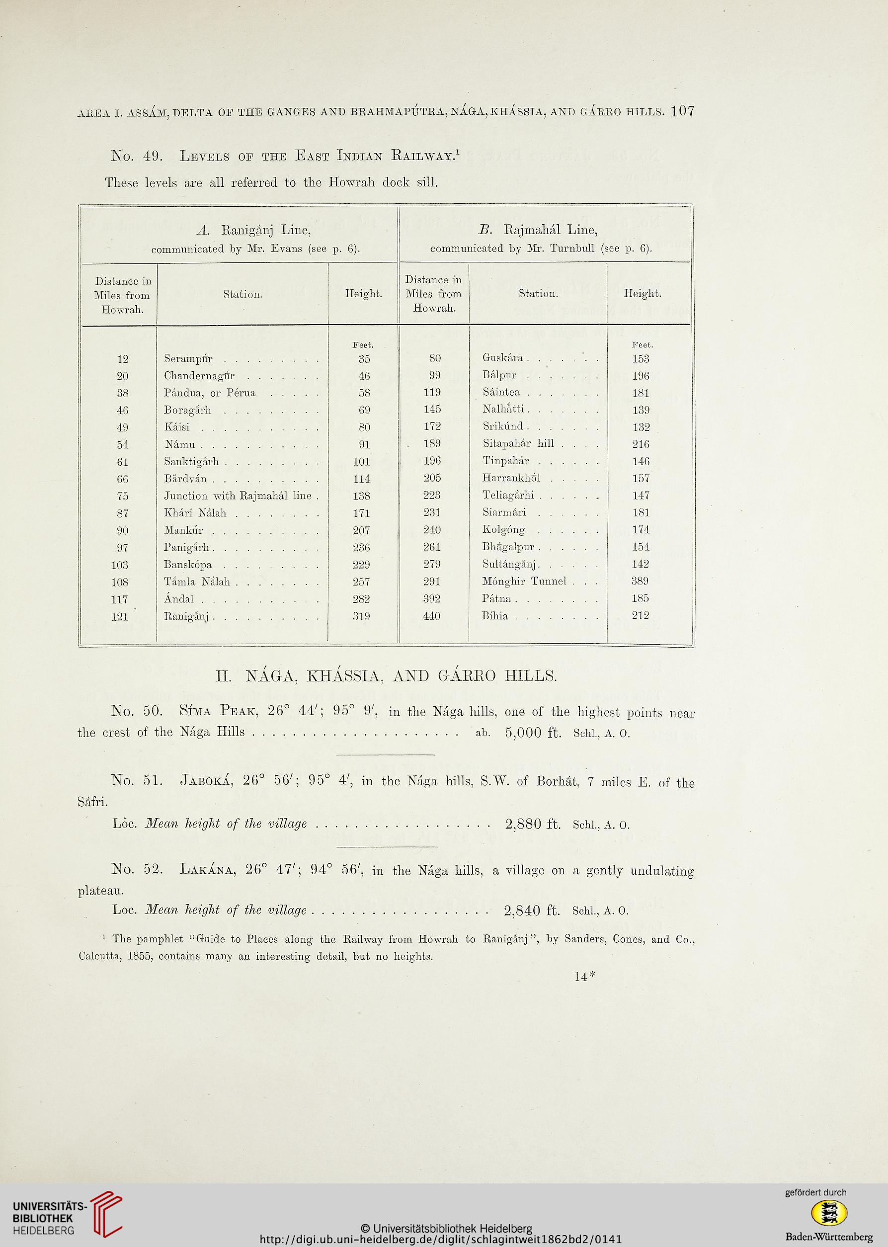
No. 49. Levels op the East Indian Railway.1
These levels are all referred to the Howrah dock sill.
A. Raniganj Line,
B. Rajmahal Line,
communicated by Mr. Evans (see
p. 6).
communicated by Mr. Turnbull (see p. 6).
Distance in
Distance in
Miles from
Station.
Height.
Miles from
Station.
Height.
Howrah.
Howrah.
Feet.
Feet.
12
35
80
153
20
Chandernagur .......
46
99
Balpur.......
196
38
Pandua, or Perua .....
58
119
Saintea.......
181
46
Boragarh.........
69
145
Nalhatti.......
139
49
Kaisi...........
80
172
132
54
91
. 189
Sitapahar hill ....
216
61
101
196
Tinpahar ......
146
66
114
205
157
75
Junction with Rajmahal line .
138
223
Teliagarbi......
147
87
Khari Nalah........
171
231
181
90
Mankur..........
207
240
Kolgong......
174
97
236
261
Bhagalpur......
154
103
229
279
Sultanganj......
142
108
Tamla Nalah........
257
291
Monghir Tunnel . . .
389
117
Andal...........
282
392
185
121 '
Raniganj..........
319
440
212
II. NAG-A, KHASSIA, AND GARRO HILLS.
No. 50. Sima Peak, 26° 44'; 95° 9', in the Naga hills, one of the highest points near
the crest of the Naga Hills..................... ab. 5,000 ft. Schl., a. 0.
No. 51. Jaboka, 26° 56'; 95° 4', in the Naga hills, S.W. of Borhat, 7 miles E. of the
Safri.
Loc. Mean height of the village.................. 2,880 ft. Schl., A. O.
No. 52. Lakana, 26° 47'; 94° 56', in the Naga hills, a village on a gently undulating
plateau.
Loc. Mean height of the village.................. 2,840 ft. Schl., a. o.
1 The pamphlet "Guide to Places along the Railway from Howrah to Raniganj ", by Sanders, Cones, and Co.,
Calcutta, 1855, contains many an interesting detail, but no heights.
14*