

DOI Seite / Zitierlink:
https://doi.org/10.11588/diglit.20836#0029


D>
Hi©F miiajuD rrdDii
o
le sSii dwt rmig©s
LpJm Ad
l T| <J
f ■ n
"l'j
n
r° f i
□>]
p
o w
0 . 1
] _ o 1:
L 1
iie 1
^—4
Lrrj
__
lava ©1
_
D1
iml
tan 8
oll
kJ
mn„ aiici
S'
(T tl
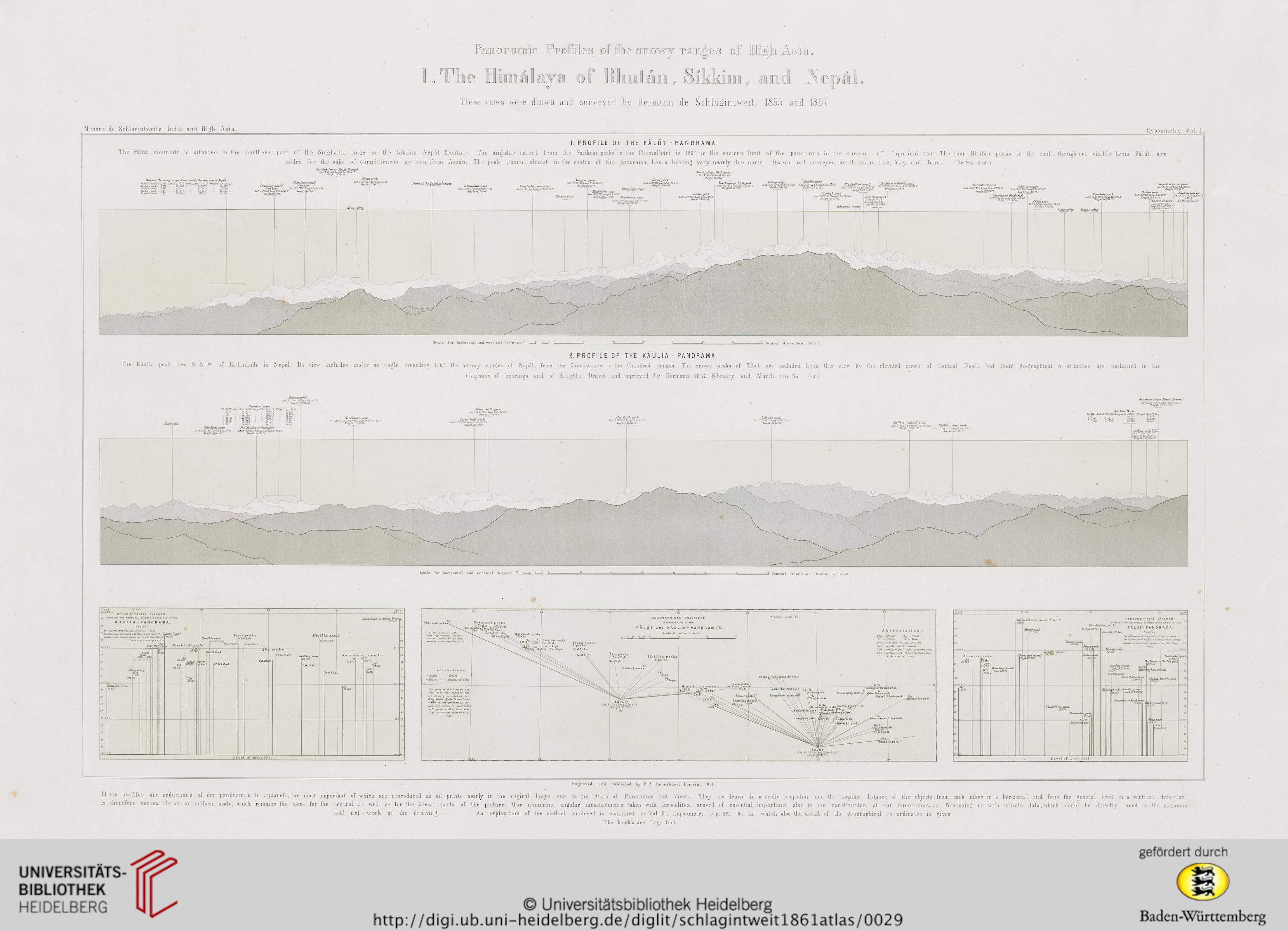
se yiews were drawn and suryeyed by Hermann de Schlaeintweit, 1855 a;nd 185/.
Messrs. de SchlaiMiitweit.s' India and Hieh Asia.
Hypsometry, Yol. H.
The Falut mountain is situated in the northern part of the Singhalila ridge on the Sihhiui - Nepai fxontier
I.PROFILE 0 F THE FALUT -PANORAMA.
The angular extent from the Sanhosi peaks to the Chamalhari is 128”, to the eastern limit of the panorama in the environs of Gipmochi 1150°. The four Bhutan peahs t.o the east, though not visible from
, are
Penks in, Uie s/iowy rantje of fhe Sapikosika, prorince ofjYepdl
SanAosi pzalc. JV.JYJF LatJflSJ’iJ:3 7onq.E.Gn8G’33 6 Ueiqht 22. 826 ft
Sankosi peak ■ XYJH . 27’.i2S ■ ■ ■ 86’22 8 21.987
Sankosl peak UX . . 2T*SS'3 . . - 86’25 1 .. 23.570..
Sankosi peak XJC ■■ 27’57'S.86’18'3 .. 23.147..
Sankosi peak .. JOCL - .. 27’57'S.86’5- 5 . 19, 560 ■■
added for the sake of completeness, as seen from Assam . The peah Jannu, almost in the centre of the panorama, has a bearing very nearly due north . Drawn and surveyed by Hermann, 1855, May and June . (Or.No. 358 )
Gaurisdnkar, or JToimt, Everesl
JtaL.7T.27‘59-3LortgJE.Gr- 86‘51.'7
UtighL.29,002 ft.
CJianildng massif
Chamldnq massip EasL peak
WesL pedli.. h aLX. 27’ki'SIongJ' Gr. 86'oS 'O
JjaluY.27‘153 LongJ].0r.86186 FugWidflMfb.
Ueiqkb22,215 !'t.
Sihsur peaJe
Jjai.jY. 27'531. LonqE.Or. 87*45
Jlt.ighJ27.7Mrt.
Pealts of Ihc lpaleda(jolo cresl
Arunvallot/
Vallan chtuv pass
Lal Y.27’58 Jo/tg E. Gr.87 V/'
Ueight tji, 756ft.
lutuqlaehe’n mountaui
Jat.JY. 97'.31'7onq.Il. Gr. 87’1I'
Vangnia peah Jannii jteale
JjaJ JY.27‘55:Jonq.E. Or.87‘52' Jjat72Y2f’408.7ong.E.6r.88 l-'8
jreijhlr.26.000h. JJeighJ2Sj304Ct.
• Chanjerma ridgt
| Ilanthoche'n, pass
\Jjat. XZ27 ‘42 ’J onqJi. Gr.&rS9-
Tampnapass [ M,iqht:ir,.,,Ofb a.uy.rma p„„,
laJJY.27‘S6'Lon)j U Gr 87‘66'
JTetghtUS.SS9 ft
Hanchinjinga I VesL peaJe
JatJY 27‘42IJ7ongTj.6rM’8'0
JUeighY 28JS6 ft.
fUgUMSU "H. JhyUMfSVH. ULKtr&U&fHiriV
ChamnlhdrL pcak
lat jr.llVl lUng.li.0r.89-<s:s r, T
Gnarcam ,or Blaek roch \
Jat JY. 27.35• Long Ji. 6r. 88 ‘4 5
JfeigliJ'lT, 556fb.
Kdhra pcak
JaL JY.27’36'5 Lnnq.K. Or. 88'5■ 8
JJeighJ' 28,015 H.
Vdrsingh pcaJt
JaL .J\ ’. 27 'YSOifLonqJi. Or. 88 ’15 0
lleighl:J9. /39 ft,
lleight .22,750ft,
lidngaidh valley
TotnoChdmopcak
fjat ..V. 27‘Iiti.
Jong.E. Or.88‘13'
U/ight 2/,0U0ft,
GipmocJu pcak
J/at.JY. 2f*17'JjonqE. 6r. 88*53-
Hrig ht: tejSOS ft.
CJidla pass
Jal.X27‘2t> JonqE Or. 88’49
Jleight 11925ft.
Tista rnllcy Jitngpo rallcy
DaJ-Ia pr GianJs ftcak
Jiat.N. 27 ‘50 ’ Lonq 11.6r. .92 ‘31 ■
Ueight 22,49611.
Odmla pcuk V Ilmlcn, l)al-tn
JaJI\.2/ J6Jjong.£.ffr..92 7■ Lal:Y.22‘S2iJjonq.E. 0r.92\
Reighl-22.430ft. j 3ti‘ 6
I Theme-ri pealv Mdghb 21,435ft.
I Iat.7Y.2r487
\ Jjonq.7. Gr. 92‘28\5.
Jleiq/iL-20.180 ft.
S v al c For horizonl aL ancL “v^ertic al cLe e e s:
Cen.tral dir e e ti o n : X o rtli.
2. PROFILE 0 F THE KAULIA - PANORAMA
Ihe Kaulia peah lies N. N .VV. oi Kathmandu in Nepal. Its view includes under an angle exceedmg 150“ the snowy ranges of Nepal, from the Gaurisankar to the Chaubissi ranges. The snowy peaks of Tibet are excluded from this view by the elevated crests of Central Nepal, but their geographieal co-ordinates are contained
diaerams of bearings and of heights. I)rawn and snrveved hy Hermann, 1857, Februarv and March. ( 0r, No . 301.)
m
the
Xdrdijani, peaks
Dha va lagir i.
Lat.N. 28“ 11 'i'lang.F.Gr. 83°28'7
JTeig/d,. 26,826 fb.
Gauris dnkar.or Jfo nnt J'lrercsl
Lai JY.27 ‘59'3 Lonq. 17.Gr.86‘31-7
Eeight 29, 002 Ft.
N’.YUII LaL.JJ.2i* 45-8 Long.F. Gr. 83’22'1 HeighL
■■ X/iir . . 28‘ 15-2 . .. 83 *2U 8 .
Sankosi Peaks
<Vo. 37X Lat .NT 27‘58'3 Long K.Gr. S6°26'i JLeight:23.670 Yt,\
,, XX 27‘57'8 .. 86*18:3 23,417 ■■
Scalc for liorizoiiiaL ancl “rertical degrees : 9——
=sP CentraT dir ection.: JNortTi Tjv East.
! fee t
8|3 'R.Qr.
8|S
HYPSOIVIETRICAL D I A G R A IVl
SHOWINO THE PRINCIPAL HEICHTS CONTAIIMED IN THE
K AULIA - PANORAIYIA.
-2B SoaLea:
For Oi/l'ej-mcjj <f Longitntle, :*2 miles -- / ineh,
r 1’ordifferencea of lieight• /•'60,OOO.or.t inctv■ 8,000 fb. Dha v/llagirL
K. ■ ■
_ 30. .0 1)0.
Gaurisdnkar, orJfount, EveresL
29,002
Dolte/L lines indicate. peatex not. visibie t'rom. Kdu.Ua,
J a rdij a ni peak s
XLYI JLT$2!J1
25. te.i\nr9ih‘.
*4212
JLYlll
x£*Xls,'m
23.779 • 23.263 j
'.Uarhiptirhd i
21727\ :
jr. :
214
g.O.-OOO_
C/iaahfssi peak
19,415
l-u
10,0
Baralhor peaks
■26.069 C.plc.
. . jj. J i Cpk.tS.TM
orsh.cad.ij pealts
-JEtrt'-j-
S4 TS0 : j 'fijHS W.pk.
Yd.ssa pe a k s
26680 X.ph.
niYUt XJJYU
JLI
22.411'
Yjar.i .22.947 P. plt.
■Jim ■
20.522
Ji bj i b i a pe a k s
\26.306 TY.pk.
25,818 S. ph.
Akit pea ks
\24,3d3 JY.pJe.
SpU.i3.313
Daibinin peak !
23,762
C.pk. 22.891
S a. tl k o s v p e a Jc s
XIX
23.570
IX
23.147
21.853U.pk.
1X1
19,560 '
JJ/I
■22,826
jvm j
\2l98r.
i e vcl of 10,000 f e et
K «• < i
XX
2.1117
S a n k 6 s ip e a k s
TJX
23,670
XYIf
'2.826
XYlll
21.98 7
0, 00 0_
XXI
1.9,560
ChamJdnq massif
IKpk. 22,215
Gaurix/mJr/ir or .Uaunl Bvcresl
29,0(12
Sfhsitr pcak
“ ‘ 799
Ckd/nJ
Kph
anq ntassif
21] 020
a peak
000
Ijiiii/iiir nc/tk
-24,660
H Y P S 0 IVI E T R I C A L DIAGR AIVI
SHOWINO THE PRINCIPAL HEIOHTS CONTAINED IN THE
itfmcliinjinqa. peaks - /■
Wtojbus FALUT - PANORAMA.
EasLpk.27.816 S c H.1 e n :
For ili/ferences ol' tongilmle :32miles • / incJi .
.Fop dUFerenccs oF heighL: /• 60.000, or 1 mch 5,000 fl.
Dolted lines i/utiraJe pea/cs not visiLle From,
Fdliib
Bdtong ri/Jge_i_J_sjl
74.957 . ]
i ChamnJkdri pcak
23.944
Panhanri,orDonkin peah
Tandfm gronp „„ . ...
22(f/T'J' ^ SSi Kinch injhdu mqssif
Pmifltm pcak
; Tdnto Chdmo ncak
21.00 0
Jajvtn pcak
25JGX --
K/ibru.n cuk
u\oi:
i VaUanrhim pass
16736
t pass
15.770
259
CAunjermii pass
V/i r sii
s/n'bh pk Pgndtm grm
J{9, J39 j pcaJe D. .119,
Guarcdpn, or B/ack
J’brkc/l Ddnki/r prak
\20.870
' 'iola m/milluin
(7.Jf/9
CJipJa pass
14.925
14.509
Gipmdrhi
HeveT of 10,000 feet
Eiigra.ved and publislicd by T’. A. Bi’ockkaus, Lerpzi£ , 1801.
lltese proiiles are reductions of our panoramas in aquarell, tlie inost important of whicli are reproduced as oii prints nearly iu the original, larger size in Ihe Atlas oi Fanoramas and Views. They are drawn in a cyclic projection, and the angular distance of the ohjects, from each other in a horizontal, and from the general level in a. vertical direction.
is therefore necessarily on an uniform scale, 'which remains the same for tlie central as well as for the lateral parls of the picture. Our numerous angular measurements taken with theodolites, proved of essential lmportance also in the construction of our panoramas, as furnishing us witli minute data, which could be directly used as the mathema
tical net - work ot tlie drawing - An. explanation of the method empioyed is contained in Arol. H, Hypsometry. p.p. 261 6, in which also thc detail of the geographical co- ordinates is given.
The lieiglvt.s are Eng. feet.
Hi©F miiajuD rrdDii
o
le sSii dwt rmig©s
LpJm Ad
l T| <J
f ■ n
"l'j
n
r° f i
□>]
p
o w
0 . 1
] _ o 1:
L 1
iie 1
^—4
Lrrj
__
lava ©1
_
D1
iml
tan 8
oll
kJ
mn„ aiici
S'
(T tl
se yiews were drawn and suryeyed by Hermann de Schlaeintweit, 1855 a;nd 185/.
Messrs. de SchlaiMiitweit.s' India and Hieh Asia.
Hypsometry, Yol. H.
The Falut mountain is situated in the northern part of the Singhalila ridge on the Sihhiui - Nepai fxontier
I.PROFILE 0 F THE FALUT -PANORAMA.
The angular extent from the Sanhosi peaks to the Chamalhari is 128”, to the eastern limit of the panorama in the environs of Gipmochi 1150°. The four Bhutan peahs t.o the east, though not visible from
, are
Penks in, Uie s/iowy rantje of fhe Sapikosika, prorince ofjYepdl
SanAosi pzalc. JV.JYJF LatJflSJ’iJ:3 7onq.E.Gn8G’33 6 Ueiqht 22. 826 ft
Sankosi peak ■ XYJH . 27’.i2S ■ ■ ■ 86’22 8 21.987
Sankosl peak UX . . 2T*SS'3 . . - 86’25 1 .. 23.570..
Sankosi peak XJC ■■ 27’57'S.86’18'3 .. 23.147..
Sankosi peak .. JOCL - .. 27’57'S.86’5- 5 . 19, 560 ■■
added for the sake of completeness, as seen from Assam . The peah Jannu, almost in the centre of the panorama, has a bearing very nearly due north . Drawn and surveyed by Hermann, 1855, May and June . (Or.No. 358 )
Gaurisdnkar, or JToimt, Everesl
JtaL.7T.27‘59-3LortgJE.Gr- 86‘51.'7
UtighL.29,002 ft.
CJianildng massif
Chamldnq massip EasL peak
WesL pedli.. h aLX. 27’ki'SIongJ' Gr. 86'oS 'O
JjaluY.27‘153 LongJ].0r.86186 FugWidflMfb.
Ueiqkb22,215 !'t.
Sihsur peaJe
Jjai.jY. 27'531. LonqE.Or. 87*45
Jlt.ighJ27.7Mrt.
Pealts of Ihc lpaleda(jolo cresl
Arunvallot/
Vallan chtuv pass
Lal Y.27’58 Jo/tg E. Gr.87 V/'
Ueight tji, 756ft.
lutuqlaehe’n mountaui
Jat.JY. 97'.31'7onq.Il. Gr. 87’1I'
Vangnia peah Jannii jteale
JjaJ JY.27‘55:Jonq.E. Or.87‘52' Jjat72Y2f’408.7ong.E.6r.88 l-'8
jreijhlr.26.000h. JJeighJ2Sj304Ct.
• Chanjerma ridgt
| Ilanthoche'n, pass
\Jjat. XZ27 ‘42 ’J onqJi. Gr.&rS9-
Tampnapass [ M,iqht:ir,.,,Ofb a.uy.rma p„„,
laJJY.27‘S6'Lon)j U Gr 87‘66'
JTetghtUS.SS9 ft
Hanchinjinga I VesL peaJe
JatJY 27‘42IJ7ongTj.6rM’8'0
JUeighY 28JS6 ft.
fUgUMSU "H. JhyUMfSVH. ULKtr&U&fHiriV
ChamnlhdrL pcak
lat jr.llVl lUng.li.0r.89-<s:s r, T
Gnarcam ,or Blaek roch \
Jat JY. 27.35• Long Ji. 6r. 88 ‘4 5
JfeigliJ'lT, 556fb.
Kdhra pcak
JaL JY.27’36'5 Lnnq.K. Or. 88'5■ 8
JJeighJ' 28,015 H.
Vdrsingh pcaJt
JaL .J\ ’. 27 'YSOifLonqJi. Or. 88 ’15 0
lleighl:J9. /39 ft,
lleight .22,750ft,
lidngaidh valley
TotnoChdmopcak
fjat ..V. 27‘Iiti.
Jong.E. Or.88‘13'
U/ight 2/,0U0ft,
GipmocJu pcak
J/at.JY. 2f*17'JjonqE. 6r. 88*53-
Hrig ht: tejSOS ft.
CJidla pass
Jal.X27‘2t> JonqE Or. 88’49
Jleight 11925ft.
Tista rnllcy Jitngpo rallcy
DaJ-Ia pr GianJs ftcak
Jiat.N. 27 ‘50 ’ Lonq 11.6r. .92 ‘31 ■
Ueight 22,49611.
Odmla pcuk V Ilmlcn, l)al-tn
JaJI\.2/ J6Jjong.£.ffr..92 7■ Lal:Y.22‘S2iJjonq.E. 0r.92\
Reighl-22.430ft. j 3ti‘ 6
I Theme-ri pealv Mdghb 21,435ft.
I Iat.7Y.2r487
\ Jjonq.7. Gr. 92‘28\5.
Jleiq/iL-20.180 ft.
S v al c For horizonl aL ancL “v^ertic al cLe e e s:
Cen.tral dir e e ti o n : X o rtli.
2. PROFILE 0 F THE KAULIA - PANORAMA
Ihe Kaulia peah lies N. N .VV. oi Kathmandu in Nepal. Its view includes under an angle exceedmg 150“ the snowy ranges of Nepal, from the Gaurisankar to the Chaubissi ranges. The snowy peaks of Tibet are excluded from this view by the elevated crests of Central Nepal, but their geographieal co-ordinates are contained
diaerams of bearings and of heights. I)rawn and snrveved hy Hermann, 1857, Februarv and March. ( 0r, No . 301.)
m
the
Xdrdijani, peaks
Dha va lagir i.
Lat.N. 28“ 11 'i'lang.F.Gr. 83°28'7
JTeig/d,. 26,826 fb.
Gauris dnkar.or Jfo nnt J'lrercsl
Lai JY.27 ‘59'3 Lonq. 17.Gr.86‘31-7
Eeight 29, 002 Ft.
N’.YUII LaL.JJ.2i* 45-8 Long.F. Gr. 83’22'1 HeighL
■■ X/iir . . 28‘ 15-2 . .. 83 *2U 8 .
Sankosi Peaks
<Vo. 37X Lat .NT 27‘58'3 Long K.Gr. S6°26'i JLeight:23.670 Yt,\
,, XX 27‘57'8 .. 86*18:3 23,417 ■■
Scalc for liorizoiiiaL ancl “rertical degrees : 9——
=sP CentraT dir ection.: JNortTi Tjv East.
! fee t
8|3 'R.Qr.
8|S
HYPSOIVIETRICAL D I A G R A IVl
SHOWINO THE PRINCIPAL HEICHTS CONTAIIMED IN THE
K AULIA - PANORAIYIA.
-2B SoaLea:
For Oi/l'ej-mcjj <f Longitntle, :*2 miles -- / ineh,
r 1’ordifferencea of lieight• /•'60,OOO.or.t inctv■ 8,000 fb. Dha v/llagirL
K. ■ ■
_ 30. .0 1)0.
Gaurisdnkar, orJfount, EveresL
29,002
Dolte/L lines indicate. peatex not. visibie t'rom. Kdu.Ua,
J a rdij a ni peak s
XLYI JLT$2!J1
25. te.i\nr9ih‘.
*4212
JLYlll
x£*Xls,'m
23.779 • 23.263 j
'.Uarhiptirhd i
21727\ :
jr. :
214
g.O.-OOO_
C/iaahfssi peak
19,415
l-u
10,0
Baralhor peaks
■26.069 C.plc.
. . jj. J i Cpk.tS.TM
orsh.cad.ij pealts
-JEtrt'-j-
S4 TS0 : j 'fijHS W.pk.
Yd.ssa pe a k s
26680 X.ph.
niYUt XJJYU
JLI
22.411'
Yjar.i .22.947 P. plt.
■Jim ■
20.522
Ji bj i b i a pe a k s
\26.306 TY.pk.
25,818 S. ph.
Akit pea ks
\24,3d3 JY.pJe.
SpU.i3.313
Daibinin peak !
23,762
C.pk. 22.891
S a. tl k o s v p e a Jc s
XIX
23.570
IX
23.147
21.853U.pk.
1X1
19,560 '
JJ/I
■22,826
jvm j
\2l98r.
i e vcl of 10,000 f e et
K «• < i
XX
2.1117
S a n k 6 s ip e a k s
TJX
23,670
XYIf
'2.826
XYlll
21.98 7
0, 00 0_
XXI
1.9,560
ChamJdnq massif
IKpk. 22,215
Gaurix/mJr/ir or .Uaunl Bvcresl
29,0(12
Sfhsitr pcak
“ ‘ 799
Ckd/nJ
Kph
anq ntassif
21] 020
a peak
000
Ijiiii/iiir nc/tk
-24,660
H Y P S 0 IVI E T R I C A L DIAGR AIVI
SHOWINO THE PRINCIPAL HEIOHTS CONTAINED IN THE
itfmcliinjinqa. peaks - /■
Wtojbus FALUT - PANORAMA.
EasLpk.27.816 S c H.1 e n :
For ili/ferences ol' tongilmle :32miles • / incJi .
.Fop dUFerenccs oF heighL: /• 60.000, or 1 mch 5,000 fl.
Dolted lines i/utiraJe pea/cs not visiLle From,
Fdliib
Bdtong ri/Jge_i_J_sjl
74.957 . ]
i ChamnJkdri pcak
23.944
Panhanri,orDonkin peah
Tandfm gronp „„ . ...
22(f/T'J' ^ SSi Kinch injhdu mqssif
Pmifltm pcak
; Tdnto Chdmo ncak
21.00 0
Jajvtn pcak
25JGX --
K/ibru.n cuk
u\oi:
i VaUanrhim pass
16736
t pass
15.770
259
CAunjermii pass
V/i r sii
s/n'bh pk Pgndtm grm
J{9, J39 j pcaJe D. .119,
Guarcdpn, or B/ack
J’brkc/l Ddnki/r prak
\20.870
' 'iola m/milluin
(7.Jf/9
CJipJa pass
14.925
14.509
Gipmdrhi
HeveT of 10,000 feet
Eiigra.ved and publislicd by T’. A. Bi’ockkaus, Lerpzi£ , 1801.
lltese proiiles are reductions of our panoramas in aquarell, tlie inost important of whicli are reproduced as oii prints nearly iu the original, larger size in Ihe Atlas oi Fanoramas and Views. They are drawn in a cyclic projection, and the angular distance of the ohjects, from each other in a horizontal, and from the general level in a. vertical direction.
is therefore necessarily on an uniform scale, 'which remains the same for tlie central as well as for the lateral parls of the picture. Our numerous angular measurements taken with theodolites, proved of essential lmportance also in the construction of our panoramas, as furnishing us witli minute data, which could be directly used as the mathema
tical net - work ot tlie drawing - An. explanation of the method empioyed is contained in Arol. H, Hypsometry. p.p. 261 6, in which also thc detail of the geographical co- ordinates is given.
The lieiglvt.s are Eng. feet.