

DOI Seite / Zitierlink:
https://doi.org/10.11588/diglit.20836#0049


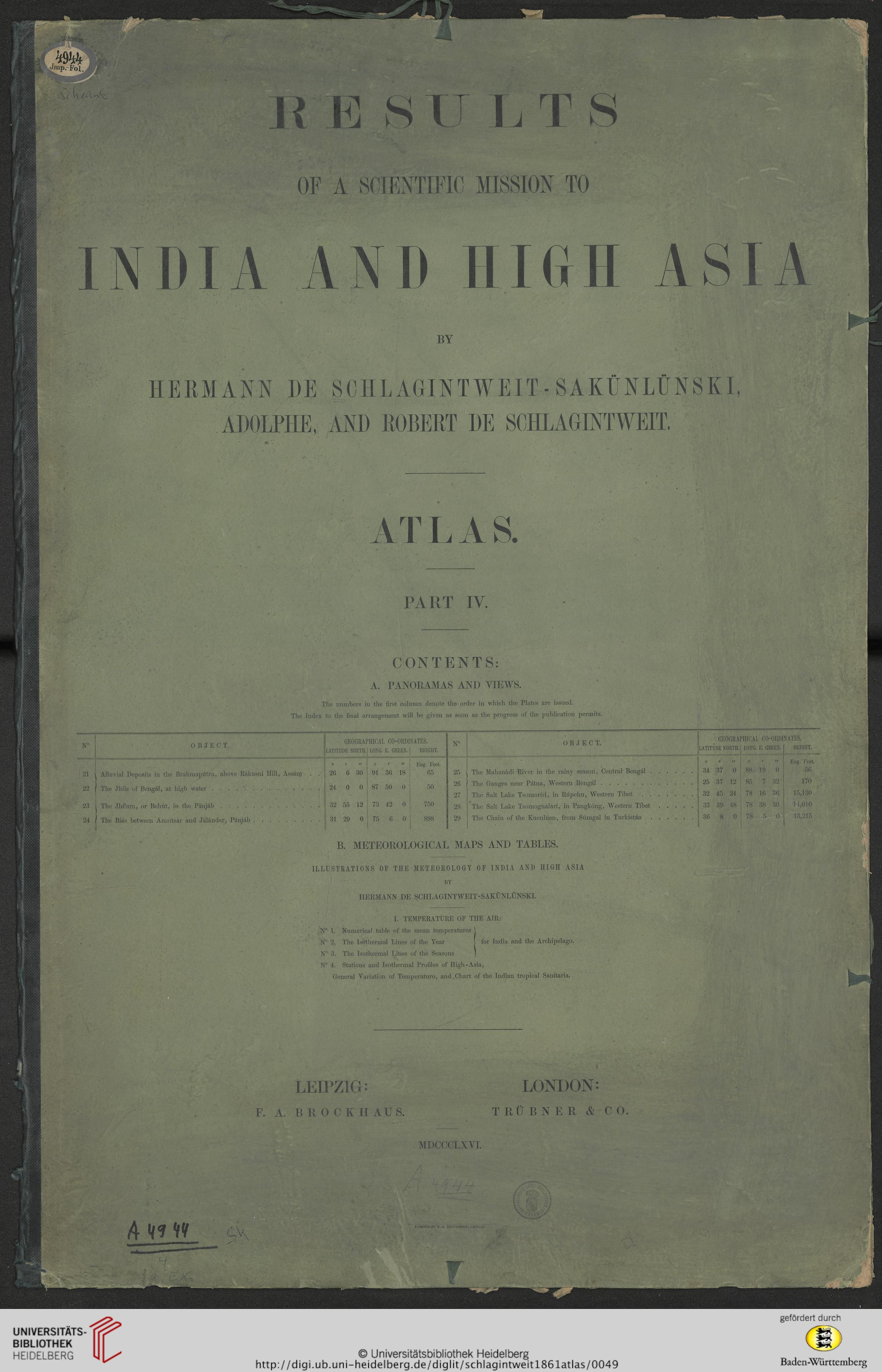
HEEMANN DE SCHLAGINTWEIT - SAKtJNLUNSKI
ATLAS.
PART IY.
CONTENTS:
A. PANORAMAS AND YIEWS.
The numbers in the first column denote the order in whicli the Plates are issued.
The Index to the final arrangement will be given as soon as tlie progress of the publication permits.
Alluvial Deposits in the Brahmaputra, above Rakusni Hill, Assam
The JhTls of Bengal, at high water..
Tlie Jhilum, or Beliut, in the Panjab ...
24 f The Bias between Amritsar and Jalander, Panjab . r .
■ •
GEOGRAPIIICAl CO-ORDINATES.
LATITUDE NORTPI.
26 6 30
24 0 0
32 55 12
31 29 0
LONG. E. GREEN.
HEIGHT.
91 36 18
87 50 0
73 42 0
75 6 0
Eng. Feet.
65
0 B J E C T.
The Mahanadi River in the rainy season, Central Bengal .
The Ganges near Patna, Western Bengal.
The Salt Lake Tsomoriri, in Rupchu, Western Tibet . .
The Salt Lake Tsomognalari, in Pangkong, Western Ti'bet
The Chain of the Kuenluen, from Sumgal in Turkistan
GEOGRAPHICAL CO-ORDINATES.
LATITUDE NORTII.
34 37 0
25 37 12
32 45 24
33 39 48
36 8 0
B. METEOROLOGICAL MAPS AND TABLES.
ILLUSTRATIONS OF THE METE0R0L06Y OF INDIA AND HI6H ASIA
HERMANN DE SCHLAGTNTWEIT-SAKUNLUNSKI
LEIPZIG •
F. A. B ROCKHAUS.
A V? 11
I. TEMPERATURE OF TIIE AIR:
N0- 1. Numerical table of the mean temperatures ]
N°- 2. The Isothermal Lines of the Year v for India and the Archipelago
N0, 3. The Isothermal Lines of the Seasons )
N° 4. Stations and Isothermal Profiles of High-Asia,
General Variation of Temperature, and .Chart of the Indian tropical Sanitaria.
LONDON:
T RU B N E R & C 0.
MDCCCLXVI
PillHTEO HY K. A. 11ROCKHAUS, J.K.'PZIO.