

DOI Artikel:
Lamb, R. C.; Rees, S. E.: Ard cultivation at Sumburgh, Shetland
DOI Seite / Zitierlink:https://doi.org/10.11588/diglit.49001#0123


ARD TRACES, SHETLAND
119
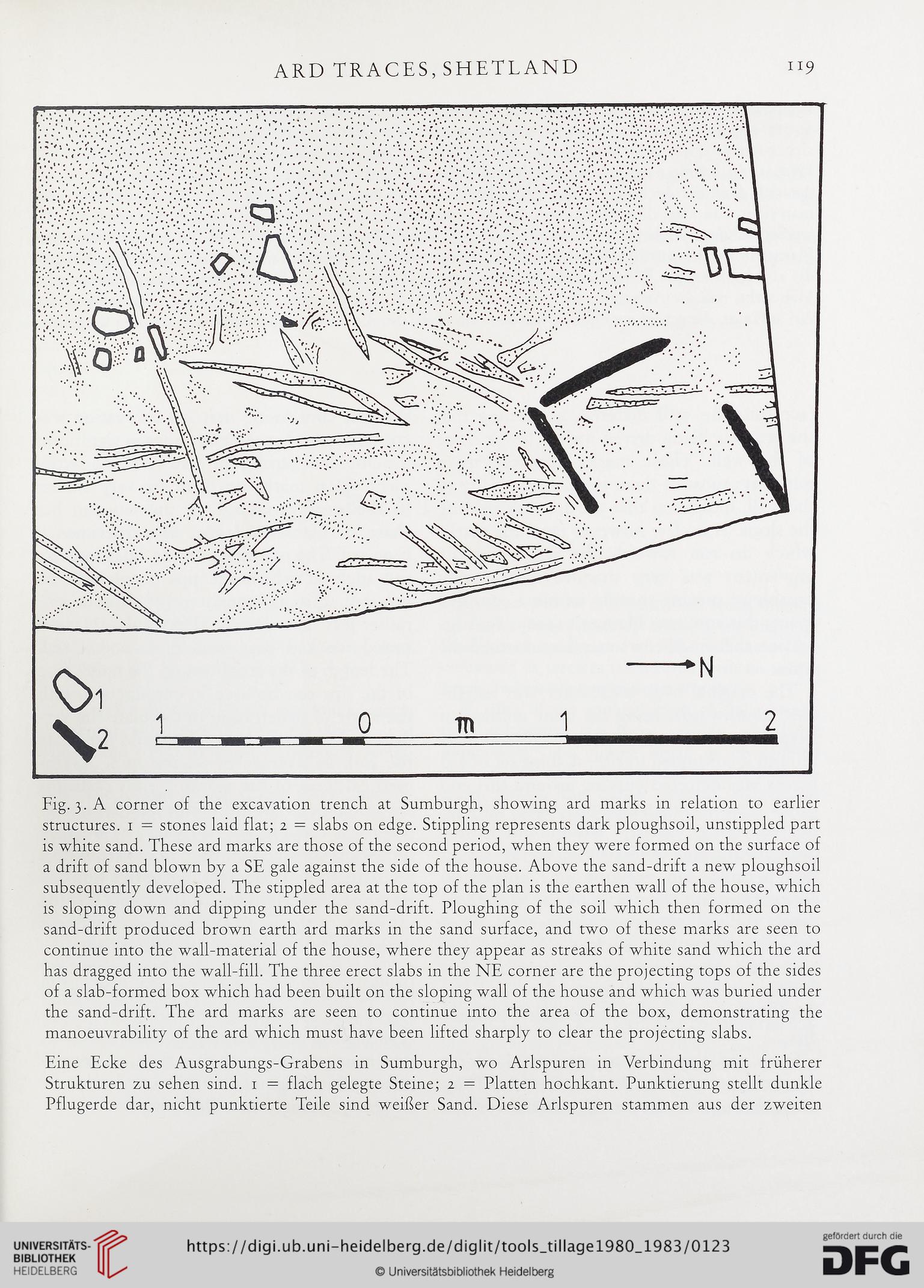
Fig. 3. A corner of the excavation trench at Sumburgh, showing ard marks in relation to earlier
structures. 1 = stones laid flat; 2 = slabs on edge. Stippling represents dark ploughsoil, unstippled part
is white sand. These ard marks are those of the second period, when they were formed on the surface of
a drift of sand blown by a SE gale against the side of the house. Above the sand-drift a new ploughsoil
subsequently developed. The stippled area at the top of the plan is the earthen wall of the house, which
is sloping down and dipping under the sand-drift. Ploughing of the soil which then formed on the
sand-drift produced brown earth ard marks in the sand surface, and two of these marks are seen to
continue into the wall-material of the house, where they appear as streaks of white sand which the ard
has dragged into the wall-fill. The three erect slabs in the NE corner are the projecting tops of the sides
of a slab-formed box which had been built on the sloping wall of the house and which was buried under
the sand-drift. The ard marks are seen to continue into the area of the box, demonstrating the
manoeuvrability of the ard which must have been lifted sharply to clear the projecting slabs.
Eine Ecke des Ausgrabungs-Grabens in Sumburgh, wo Arlspuren in Verbindung mit fruherer
Strukturen zu sehen sind. 1 = flach gelegte Steine; 2 = Flatten hochkant. Punktierung stellt dunkle
Pflugerde dar, nicht punktierte Telle sind weiher Sand. Diese Arlspuren stammen aus der zweiten
119
Fig. 3. A corner of the excavation trench at Sumburgh, showing ard marks in relation to earlier
structures. 1 = stones laid flat; 2 = slabs on edge. Stippling represents dark ploughsoil, unstippled part
is white sand. These ard marks are those of the second period, when they were formed on the surface of
a drift of sand blown by a SE gale against the side of the house. Above the sand-drift a new ploughsoil
subsequently developed. The stippled area at the top of the plan is the earthen wall of the house, which
is sloping down and dipping under the sand-drift. Ploughing of the soil which then formed on the
sand-drift produced brown earth ard marks in the sand surface, and two of these marks are seen to
continue into the wall-material of the house, where they appear as streaks of white sand which the ard
has dragged into the wall-fill. The three erect slabs in the NE corner are the projecting tops of the sides
of a slab-formed box which had been built on the sloping wall of the house and which was buried under
the sand-drift. The ard marks are seen to continue into the area of the box, demonstrating the
manoeuvrability of the ard which must have been lifted sharply to clear the projecting slabs.
Eine Ecke des Ausgrabungs-Grabens in Sumburgh, wo Arlspuren in Verbindung mit fruherer
Strukturen zu sehen sind. 1 = flach gelegte Steine; 2 = Flatten hochkant. Punktierung stellt dunkle
Pflugerde dar, nicht punktierte Telle sind weiher Sand. Diese Arlspuren stammen aus der zweiten