

DOI article:
Lerche, Grith: A century old survey of "Celtic" fields in Jutland
DOI Page / Citation link:https://doi.org/10.11588/diglit.49002#0062


60
GRITH LERCHE
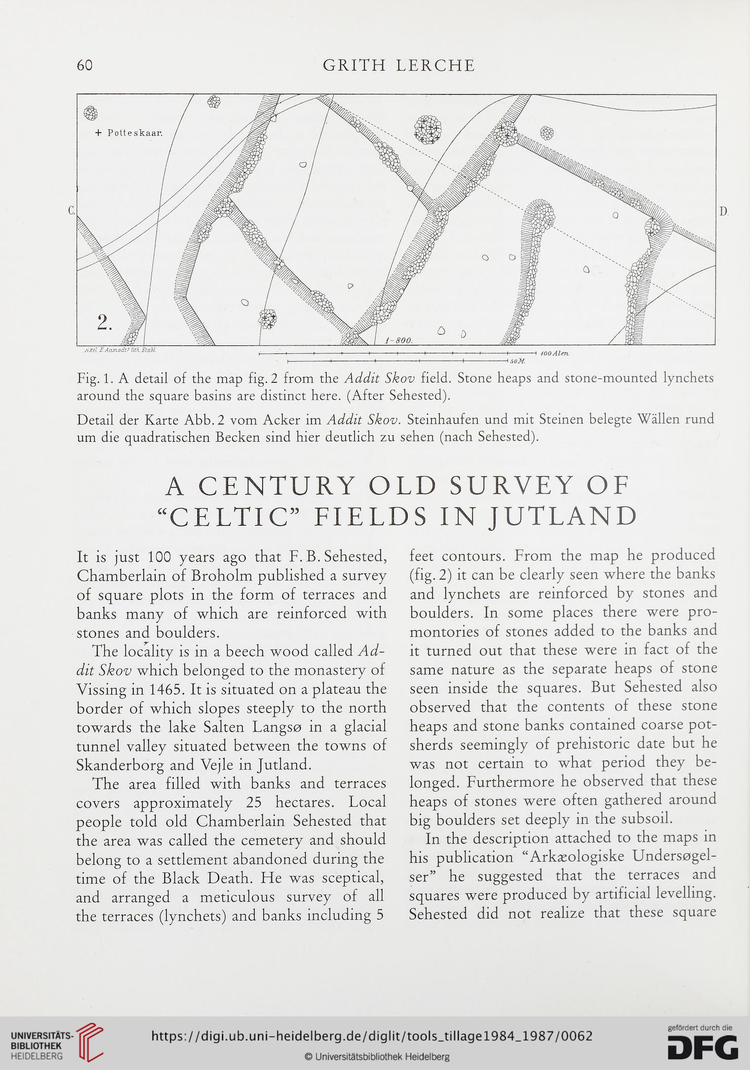
Fig. 1. A detail of the map fig. 2 from the Addit Skov field. Stone heaps and stone-mounted lynchets
around the square basins are distinct here. (After Sehested).
Detail der Karte Abb. 2 vom Acker im Addit Skov. Steinhaufen und mit Steinen belegte Wallen rund
um die quadratischen Becken sind hier deutlich zu sehen (nach Sehested).
A CENTURY OLD SURVEY OF
“CELTIC” FIELDS IN JUTLAND
It is just 100 years ago that F. B. Sehested,
Chamberlain of Broholm published a survey
of square plots in the form of terraces and
banks many of which are reinforced with
stones and boulders.
The locality is in a beech wood called Ad-
dit Skov which belonged to the monastery of
Vissing in 1465. It is situated on a plateau the
border of which slopes steeply to the north
towards the lake Salten Langso in a glacial
tunnel valley situated between the towns of
Skanderborg and Vejle in Jutland.
The area filled with banks and terraces
covers approximately 25 hectares. Local
people told old Chamberlain Sehested that
the area was called the cemetery and should
belong to a settlement abandoned during the
time of the Black Death. He was sceptical,
and arranged a meticulous survey of all
the terraces (lynchets) and banks including 5
feet contours. From the map he produced
(fig. 2) it can be clearly seen where the banks
and lynchets are reinforced by stones and
boulders. In some places there were pro-
montories of stones added to the banks and
it turned out that these were in fact of the
same nature as the separate heaps of stone
seen inside the squares. But Sehested also
observed that the contents of these stone
heaps and stone banks contained coarse pot-
sherds seemingly of prehistoric date but he
was not certain to what period they be-
longed. Furthermore he observed that these
heaps of stones were often gathered around
big boulders set deeply in the subsoil.
In the description attached to the maps in
his publication “Arkaeologiske Undersogel-
ser” he suggested that the terraces and
squares were produced by artificial levelling.
Sehested did not realize that these square
GRITH LERCHE
Fig. 1. A detail of the map fig. 2 from the Addit Skov field. Stone heaps and stone-mounted lynchets
around the square basins are distinct here. (After Sehested).
Detail der Karte Abb. 2 vom Acker im Addit Skov. Steinhaufen und mit Steinen belegte Wallen rund
um die quadratischen Becken sind hier deutlich zu sehen (nach Sehested).
A CENTURY OLD SURVEY OF
“CELTIC” FIELDS IN JUTLAND
It is just 100 years ago that F. B. Sehested,
Chamberlain of Broholm published a survey
of square plots in the form of terraces and
banks many of which are reinforced with
stones and boulders.
The locality is in a beech wood called Ad-
dit Skov which belonged to the monastery of
Vissing in 1465. It is situated on a plateau the
border of which slopes steeply to the north
towards the lake Salten Langso in a glacial
tunnel valley situated between the towns of
Skanderborg and Vejle in Jutland.
The area filled with banks and terraces
covers approximately 25 hectares. Local
people told old Chamberlain Sehested that
the area was called the cemetery and should
belong to a settlement abandoned during the
time of the Black Death. He was sceptical,
and arranged a meticulous survey of all
the terraces (lynchets) and banks including 5
feet contours. From the map he produced
(fig. 2) it can be clearly seen where the banks
and lynchets are reinforced by stones and
boulders. In some places there were pro-
montories of stones added to the banks and
it turned out that these were in fact of the
same nature as the separate heaps of stone
seen inside the squares. But Sehested also
observed that the contents of these stone
heaps and stone banks contained coarse pot-
sherds seemingly of prehistoric date but he
was not certain to what period they be-
longed. Furthermore he observed that these
heaps of stones were often gathered around
big boulders set deeply in the subsoil.
In the description attached to the maps in
his publication “Arkaeologiske Undersogel-
ser” he suggested that the terraces and
squares were produced by artificial levelling.
Sehested did not realize that these square